Drones Hover Over $100B Industry
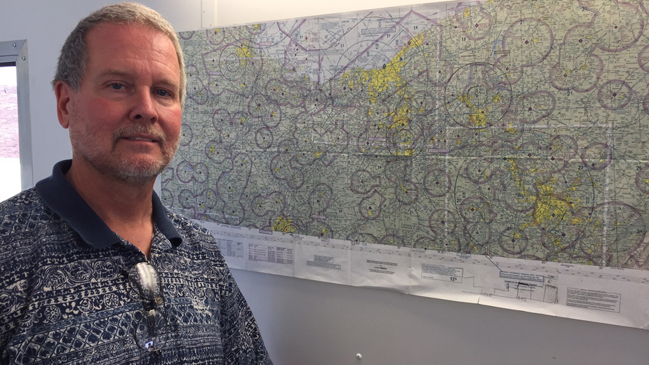
YOUNGSTOWN, Ohio – Richard Hassler points to an elongated map of northeastern Ohio and western Pennsylvania. To the untrained eye, the map is merely a display of dozens of concentric circles, each one numbered, interconnected with thin, diagonal lines akin to bicycle spokes crisscrossing the entire region.
A closer look reveals that this is no typical map. Rather, it’s a schematic of aviation airspace, with each circle representing an area around small and large metropolitan airports across the region.
It’s this map that not only guides airline pilots, but also the operators of much smaller devices. In this case, those smaller aircraft are unmanned drones, which hover over an industry that’s projected to climb to $100 billion by 2020 – and will need specially trained pilots.
“You have to learn airspace systems, aerodynamics, federal aviation regulations, what the restrictions are – there’s a lot that goes into it,” says Hassler, coordinator for Robotics and Advanced Manufacturing Training, or Ramtec, at the Mahoning County Career and Technical Center in Canfield.
This fall, Hassler kicks off what he believes is the first high school-based flight training program in the region that’s dedicated to drones. “I’m going to take them through an FAA Part 107 course,” he says. “By the end of the semester, they’ll be able to take their knowledge test to fly unmanned aircraft systems commercially.”
Hassler is among those in the Mahoning Valley who project that demand for drone pilots, operators and related information technology specialists will expand significantly in the near term. But he suggested the new course almost as an afterthought.
“MCCTC superintendent John Zehentbauer approached me and asked me what I’d like to see in our program,” Hassler recalls. “Just out of the blue, I told him a drone. He loved the idea.”
According to the FAA, the number of commercial drones operating in the United States could reach 420,000 by 2021. Two years ago, there were just 42,000 commercial drones in the air.
Meanwhile, the drone hobby market enjoys tremendous growth. The FAA estimates the number of recreational drones could hit 3.5 million by 2021.
Drones have become so ubiquitous that they inspired Time magazine to devote a recent issue to exploring how these aircraft impact wildlife preservation, security, law enforcement, agriculture and public safety.
Flying any sort of drone for compensation requires a Part 107 certificate, Hassler says, which is obtained by sitting for an informational test required by the FAA. Once obtained, a pilot could use drones for commercial purposes with a full understanding of federal regulations.
For example, regulations as they stand mandate that drones cannot fly above 400 feet, unless a waiver is granted. Nor can a pilot fly the aircraft beyond the operator’s line of sight.
And those concentric rings found around airports on flight maps? These essentially demark no-fly zones – a radius of about five miles around major municipal airports with heavy traffic. Under current FAA law, a drone pilot cannot operate within five miles of such airports unless granted the go-ahead from the flight tower.
“If you do it without notifying them, then you’ve got trouble,” Hassler says. However, drone pilots are not encumbered with these regulations around smaller airports without control towers.
The advent of drone technology has opened up new opportunities for a host of business segments across the U.S. economy. Think Amazon for package delivery, for starters.
Safety forces now use drones for search and rescue operations and crime-scene investigations. Farmers use them for spraying pesticides and to detect potential crop fungus and disease through thermal imaging. Media organizations routinely use them to obtain better visuals. And real estate agents find them valuable to capture the full breadth of a property on the market.
“We use them all the time,” says Marlin Palich, broker at Northwood Realty Ohio. “Most people are visual and the best thing about a drone is that it gives an overview of the entire area.”
That’s important when it comes to selling a home, large estate or farm, especially in the age of digital marketing, Palich says. “We’ve been using drones for about the past four years,” he says. “We want to give our agents the best tools and the buyer the best information.”
An aerial view of a neighborhood, for example, could identify the proximity of a school, park, recreational facilities or other amenities that might be of interest to a homebuyer, Palich says.
More importantly, the images can be uploaded immediately to digital marketing platforms for customers to view. Recently, Northwood Realty used a drone to market an upscale condominium. “It had a clubhouse, tennis courts, a pool – the drone took it all in,” he says.
Another transaction involved the sale of a large horse farm, Palich says. The use of a drone enabled prospective buyers to get a bird’s-eye view of the entire property, including the layout of the barns, the riding area, and the house. And the use of smaller drones makes it possible to fly inside of some of the large barns in order to provide visuals of their interiors, he adds.
“It’s not cheap,” Palich says. “But how business is done today is very different. It’ll never go backwards.”
Demand for drone usage and operators is only going to increase, says Jack Yakovich, acting dean of the aviation science center at the Community College of Beaver County.
The college is in the early stages of developing a two-year degree program that combines its licensed pilot curriculum with a drone certification. “It makes the students more marketable,” he says.
Several alumni of the program are employed as drone pilots by private companies or have secured internships working for video production firms that are contracted for drone capabilities. “One of our former students is working for a company that expects to hire 16 drone pilots,” Yakovich says.
Others are in the process of working on a documentary, while several students in the program have landed an internship with a firm that is working with local agriculture. “Agriculture is huge,” Yakovich says. “That’s starting to pick up.”
Yakovich says the Beaver County program incorporates practice on more sophisticated drone technology and it’s much more involved than spending a weekend studying for a Part 107 test.
“Some of the drones they’re flying have six propellers and can pick up more than 60 pounds,” he says.
About 30 are enrolled in the unmanned aerial vehicle program, Yakovich reports, and in all about 225 are enrolled in the school’s aviation sciences department.
“I think it’s going to grow leaps and bounds, at least in the near future,” he says.
The No. 1 market for drones in the United States and abroad is still military and defense, according to a recent report issued by Goldman Sachs.
By 2020, the entire drone business should command $100 billion in revenue, $70 billion of which is expected to come from the defense industry.
According to the survey, another $17 billion would be dominated by the general consumer market, while $13 billion worth of business would be generated by the commercial and government sectors – the fastest-growing segment.
Construction, agriculture, insurance, oil and gas, and local government safety forces provide the most opportunity for drone use. Other companies are putting drones to use in order provide a more comprehensive menu for potential customers in both heavy industry and media.
“We’re using this to augment business with clients in the industrial sector,” says Brad Garwacki, chief operating officer of Globex Inc., Canfield.
Globex conducts inspections of industrial plants and facilities across the region and then provides the information to the operation’s executives so they can take action to address a potential problem before it gets worse.
The company started using drones last year to help the inspection process, especially in areas where it would be difficult to reach without a large boom crane, he says.
“One of the new things we’re doing is analyzing industrial stacks with thermography,” Garwacki says. The company’s drone is able, for example, to reach a sufficient altitude and zoom in close enough to the stack in order to obtain a detailed video or picture of any possible damage.
“The drone allows you to get closer within an arm’s reach away and get better readings,” he says.
Thus, the use of a drone would end up saving the client the trouble of renting a large crane or to have a maintenance worker scale the stack in order to provide a physical inspection. “It saves them a ton of money,” he says. “It’s a cursory inspection to see if you need to take the next step to do any repair work.”
Garwacki says the company averages about two or three inspections per month using its drone.
Aaron Campbell, drone pilot for Globex, says the market for drones in the Mahoning Valley is not as robust when compared to the rest of the country. “We’re starting to catch up. In other parts of the country, they’re doing this regularly.”
Still, the technology helps smaller companies, especially those engaged in video and digital production, by providing them with capabilities that were once the domain of big studios.
“We’re using them as add-ons to the spots we’re creating,” says Chris Jaskiewicz, president of Advantage Video Production, Youngstown.
The multimedia marketing company produces television and digital commercials for clients across the Mahoning Valley and the use of drone technology enables Advantage to better market itself to new clients.
“A lot of auto dealers, for example, like to show off their inventory,” he says. Banks, companies with large facilities and industrial customers, even cities and parks, have used the company for promotional videos.
“If anyone is proud of their location, then we use the drone.”
Pictured: Richard Hassler stands before a map depicting flight paths and airspace that drones use across the region.
Copyright 2024 The Business Journal, Youngstown, Ohio.